Location: Redwood City, San Mateo County
Hike Date: 2017, June 28, Wednesday, 10:10 am
Hike Stats: 6.4 miles, 2.5 hours, 1375 feet elevation gain
Repeat Visit: 2019, May 4, Saturday
 “The panoramic view of the seemingly never-ending valleys leading to the coast is spectacular. On a clear day, visibility extends to the ocean.” (text source: mrosd)
FEATURES
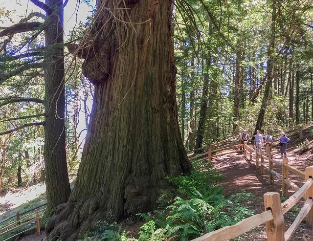
- Redwood and Douglas fir forest, featuring old growth redwood trees. The Methuselah Tree is one of the very few remaining old growth redwood trees.
- Tafoni sandstone formations (not on this route though; one would need to take the Tafoni Trail to view them.)
ABOUT THE HIKE
I went for this hike with Midpeninsula Regional Open Space District’s docents Fran Keeler, Huey-Shin Yuan, and Mary Brunkhorst (Scenic Aerobic Hike II). In all, there were ten hikers. It was a brisk-paced hike with no planned rest stops.
This is a great place to go to in the summer months to enjoy a leisurely hike in the shade of redwood trees. Compared to other open space preserves, this place is a more complicated maze of numerous crisscrossing trails; one can easily get lost if the route is not planned in advance or if not carrying a map. This preserve is frequented by many hikers and cyclists on week days.
The sight of the Methuselah Tree was absolutely fascinating. One can avoid all the hiking and just drive up to the spot – it is off the Skyline Blvd.
- Parking Lot: El Corte de Madera Creek Open Space Preserve parking lot with ample parking space. There is some cellular reception inside the preserve.
- Parking Fee: None
- Restroom: Two, both next to the parking lot/trailhead (‘A’ in the route below)
- Trailhead: Next to the parking lot
- Exposure: Completely shaded, very few parts exposed for a very short distance
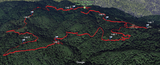
- Route (clockwise):
- Trailhead (A) –> Sierra Morena Trail (B)
- Left at the fork –> Oljon Trail (C)
- Right at the T-junction –> Steam Donkey Trail (D)
- Right at the fork –> Gordon Mill Trail (E) –> T-junction soon after, keep left to stay on ‘E’
- Right at the fork –> Crossover Trail (F)
- Left at the T-junction –> Crosscut Trail (G)
- Right at the T-junction –> Timberview Trail (H)
- Left at the fork –> Manzanita Trail (I)
- Right at the four-way junction –> Methuselah Trail (J)
- Left at the fork to keep on ‘J’ –> Sierra Morena Trail (K) (next to Skyline Blvd / Hwy 35) –> cross the highway to visit the Methuselah Tree
- Back to ‘K’ — repeat of a part of ‘B’
- Route Map:
- Terrain Profile:
HIKE STATS
- Distance: 6.4 miles
- Time: 3 hours 10 minutes (Moving Time: 2 hours 35 minutes)
- Avg Moving Pace: 24:25 min/mi
- Elevation Gain: 1375 feet
- Elevation Profile:


2 thoughts on “El Corte de Madera Creek Open Space Preserve”