Location: Morgan Hill, Santa Clara County
Hike Date: 2020, January 24, Friday, 01:00 pm
Hike Stats: 8 miles, 3 hours 30 min, 1705 feet elevation gain
Gear:
* Shoes: Patagonia Drifter (Vibram)
* Tracking: Garmin Forerunner 235
* Trekking Poles: Black Diamond Distance Carbon Z
* Hydration Pack: CamelBak Women’s 2016 Day Star 18
TOP
PARKING
There is a designated Parking Lot to the left of the Casa Loma Rd if you are coming from the north. The spots are limited.
There is no parking fee.
RESTROOM
There is a single restroom on the right-hand side of the parking lot. The restroom was clean with supplies of toilet seat cover, toilet paper, hand sanitizer.
TRAILHEAD
There are two trailheads to the left of the restroom (facing the restroom). The one on the left leads to Llagas Creek Loop Trail and the one on right leads to the Mayfair Ranch Trail. There are trail signboards to help.
The Mayfair Ranch Trail starts on the left of the restroom and goes behind the restroom, across the Casa Loma Rd. There are preserve maps and signboards across the Casa Loma Road to get you started on the Mayfair Ranch Trail.
EXPOSURE
Mostly exposed, some trails are shaded
OFFICIAL TRAIL MAP
ABOUT THE PRESERVE
- Brief History: “Peninsula Open Space Trust (POST) protected this property in 1999 and soon after transferred ownership to the Santa Clara Valley Open Space Authority for permanent management. The preserve was open to the public in 2004.”
- Trails for hiking, mountain biking, and horse riding (see official map to see trails designated for each type of use). Dogs are not allowed in this preserve
- Connected to the Calero County Park in the north and also close to Almaden Quicksilver County Park.
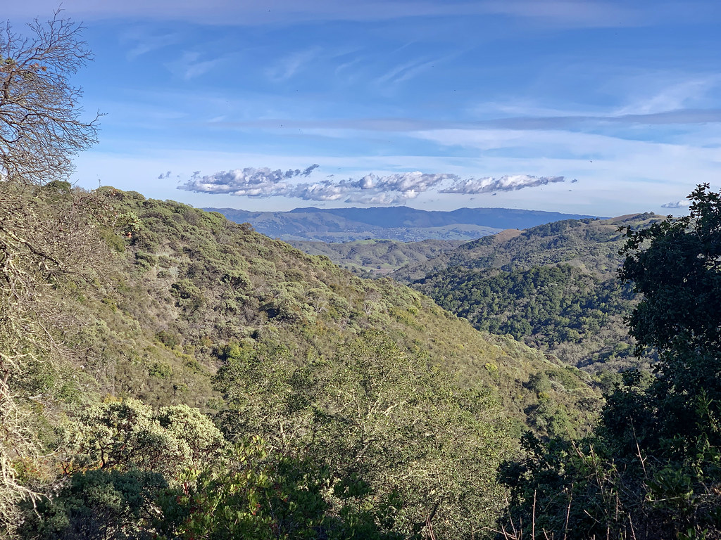
- Offers panoramic views of the valley, sweeping vistas of the Santa Cruz mountains
- Oaks, walnut trees, open grasslands, bobcats, wolves, wild turkeys, deers, wildflowers
- The Llagas Creek Loop Trail is paved and accessible for visitors with limited mobility.
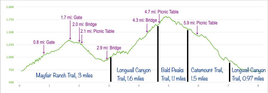
- There are 3 picnic tables on the route described here. They are also tagged in the route map linked here.
- Creeks: Llagas Creek, Baldy Ryan Creek (bridges to cross over)
ABOUT MY HIKE
SOLO HIKE: I started late (1 pm). With a conservative estimate of 2 miles/hour, I hoped to complete the 8-mile hike in 4 hours (by 5 pm), giving me half-an-hour buffer before sunset. I was rushing all the way through just to make it back to the parking lot before sunset. Managed to complete the hike by 4:30 pm.
BOBCAT: Walking uphill on the Mayfair Ranch Trail, I happened to see a bobcat at some distance, off the trail and minding its business. It looked like a youngling. My presence probably startled it as much as I was startled on spotting it. My instant reaction was to follow the instructions at every preserve’s entrance: appear bigger and do not run if you encounter a bobcat or a mountain lion. So I raised my arms and also raised the hiking sticks to appear bigger. The bobcat scooted a bit but then stopped to look back at me. I repeated the ‘appear bigger’-gesture and it finally disappeared for good.
CROWD: I did not come across any other hiker on the entire route. The only humans I met were cyclists, six in all.
Soon after my bobcat-encounter, a cyclist passed me. He had seen me trying to chase it away. I ran into the same cyclist again towards the end of my hike, roughly 3 hours later. He stopped this time and we chatted a bit. He showed me pictures and video of a fox that was right in front of him on the trail! (I felt lucky to have skipped the fox-rendezvous). The second cyclist who passed me was a mountain ranger who stopped to check on me. We briefly discussed the route I was planning and an estimate on when I would complete the loop.
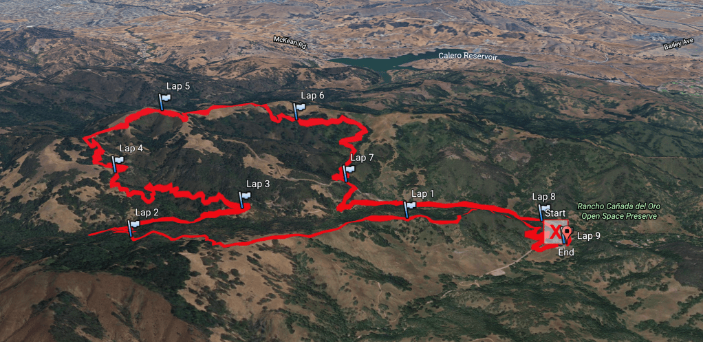
ROUTE (LOOP, CLOCKWISE)
SUMMARY
(A) Parking Lot/Trailhead
(B) Mayfair Ranch Trail
(C) Longwall Canyon Trail
(D) Bald Peaks Trail
(E) Catamount Trail
(F) Longwall Canyon Trail
DETAILED
- (A) Trailhead >>> Take the trail to the left of the restroom that takes you up to the Casa Loma Rd and walk across the road to get started on the (B) Mayfair Ranch Trail.
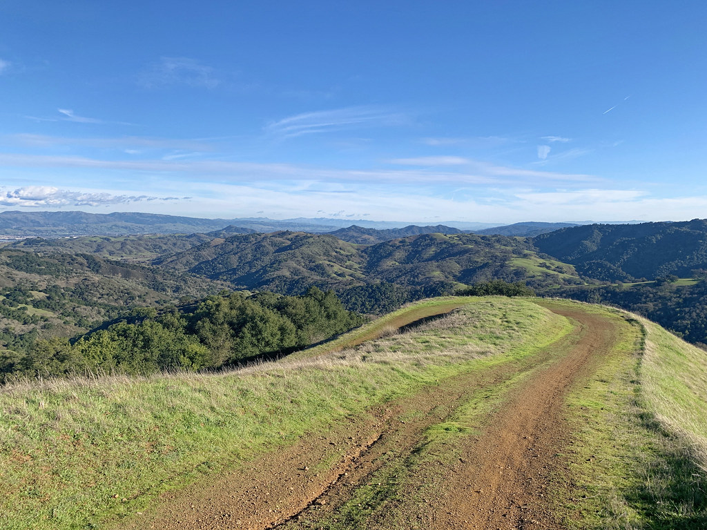
- The Mayfair Ranch Trail starts with a couple of switchbacks, with some shaded and some exposed portions.
- This single-lane wide dirt trail keeps increasing in elevation and passes through manzanita woodlands.
- After the first gate (to keep out the grazing cattle), the trail runs through open grassland with sweeping vistas, interspersed with groves of Blue Oak. I did not see any cows anywhere on the hiking route.
- After the second gate, the trail becomes shaded and you come across a wooden creek crossing.
- Soon after, there is a picnic table. This rest stop provides shade and also some scenic views before you climb some more switchbacks.
- After the switchbacks, the Mayfair Ranch Trail runs alongside the Baldy Ryan Creek. There is a steel bridge to cross over the creek.
- Turn left on the T-junction to join the (C) Longwall Canyon Trail.
- The second surge of climbing happens on this stretch of trail, almost 800 feet elevation gain.
- This trail is also shaded and exposed in parts.
- It offers some panoramic views of the Santa Cruz mountains.
- After 1.5 miles of the meandering, you come across a wooden bridge where the trail again comes in contact with the Baldy Ryan Creek.
- Keep going straight on the next junction to join the (D) Bald Peaks Trail.
- There is a very well-shaded picnic table. Take a break here after all the climbing (I could not because I did not have the time 😦 ).
- Just 0.3 miles later, you can climb the Bald Peaks (a small trail on the left) to take in the valley views from the top. I skipped this. From this point on, you keep descending gradually.
- At the fork, keep going straight on the Bald Peaks Trail.
- After 1.0 miles, turn right to get on the (E) Catamount Trail.
- In 0.5 miles, there is a picnic table.
- This trail is quite uncharacteristic, except that it descends steeply with a few stretches of moderate descent.
- Keep following trail markers to stay on the Catamount Trail.
- After 1.5 miles, the Catamount Trail joins the (F) Longwall Canyon Trail.
- This trail eventually enters Calero Park.
- The trail leads to the parking lot across the Casa Loma Rd.
ROUTE MAP (LOOP, CLOCKWISE)
ELEVATION PROFILE OVER DISTANCE (MILES)
TERRAIN PROFILE (GOOGLE EARTH)
SHOTS FROM THE HIKE


I love that there is a paved trail accessible for visitors with limited mobility.