Location: Cupertino, Santa Clara County
Loop II: Rogue Valley – Wildcat Loop – Upper High Meadow – Upper Wildcat Canyon
Hike Date: 2017, February 16, Thursday, 2:00 pm
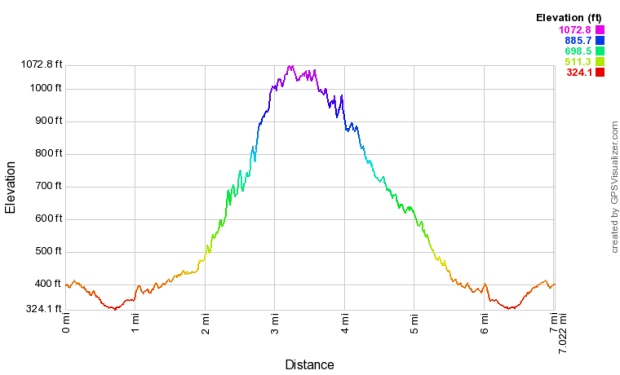
Hike Stats: 7 miles, 2 h 45 min, 1029 feet elevation gain
Previous Visits: 2017: March 18, March 23, April 12, June 3
Loop III: 5-mile loop via the inner Wildcat Loop Trail
Hike Dates: 2019-September-8, 2019-October-4, 2019-October-11
“The preserve’s extensive 24 miles of trails are available for exploration, whether one chooses to hike (dogs, however, are NOT permitted), bike, or horseback ride. Trails can be combined to form loops of different lengths and difficulties including the 3-mile Wildcat Loop Trail and the 4-mile Black Mountain Trail.
A highlight of the preserve is Deer Hollow Farm, a working farm with turn-of-the-century ranch buildings, an organic garden and a cow, pigs, goats, sheep, chickens and other animals.” (text source: mrosd)
FEATURES
- A popular spot for hiking and trail running
- Provision for cycling and equestrian access on designated trails
- A model aircraft field next to the parking lots on Rancho San Antonio Service Rd
- Small picnic area with tables and barbecues
- Deer Hollow Farm
ABOUT THE HIKE
This is the preserve where I started hiking and learned what hiking is! Some of my earlier attempts solo and with my husband are captured here and here (Loop I).
This is the go-to preserve for when my husband and I want to head outdoors or when I want to go for a solo hike and do not have the time to plan a hike at another park. This preserve is also only a 20-minute drive from home and offers a good amount of shade on hot days. It remains equally busy on weekdays, that’s how popular it is, and which also ensures that I am not in a solitary far off place when I go alone.
There are so many trails of different difficulties here, so one can literally mix and match them to suit how long one wants to hike on a particular day.
- Parking Lot: There are a couple of parking lots but all of them can get full pretty quickly over the weekend. I usually first try the Parking Lots for Deer Hollow Farm. This is also the only parking lot with a restroom. On the way to this parking lot along the Rancho San Antonio Service Rd, there are three more parking lots, where I try to get a spot next if the first one is full. There is also an Equestrian Parking lot, the first one when you turn off from Cristo Rey Dr.
- Parking Fee: None
- Restroom: There is one next to the parking lot linked above. The second one is around one mile inside the preserve near the Deer Hollow Farm.
- Trailhead: Next to the parking lot linked above.
- Exposure: Mostly shaded, some parts exposed.
- Route (Loop):
- Summary: Parking Lot – Permanente Creek Trail – Lower Meadow Trail – Rogue Valley Trail – Wildcat Loop Trail – Upper High Meadow Trail – Upper Wildcat Canyon Trail – Wildcat Loop Trail – Coyote Trail – Farm Bypass Trail – Lower Meadow Trail – Permanente Creek Trail
- Detailed:
- Trailhead (A) –> Right at the fork for the Permanente Creek Trail (B).
- Keep left to join the Lower Meadow Trail (C), which runs parallel to the Rancho San Antonio Service Rd.
- Continue on the Lower Meadow Trail as it turns right and goes past the Deer Hollow Farm.
- After the farm, continue straight past a gate on to the Rogue Valley Trail (D).
- Left at fork –> Wildcat Loop Trail (E) –> seven switchbacks that are marked on the wooden fence.
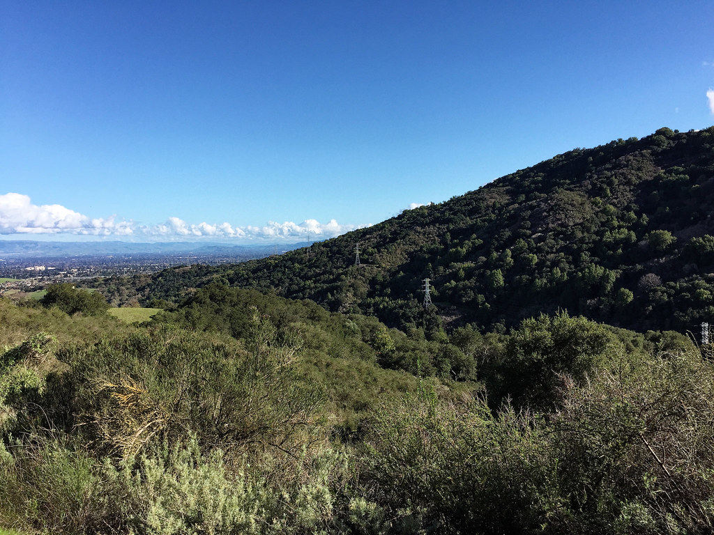
- At the 4-way junction, you can go straight up the incline to the High Meadow Vista Point. This point gives a 360-degree view of the Bay Area.
- First right (or second left if coming from the Vista Point) –> Upper High Meadow Trail (F).
- Left at the fork –> Upper Wildcat Canyon Trail (G).
- Right at the fork –> Wildcat Loop Trail (H) [both the forks are named the same]
- Stay on Wildcat Loop Trail at the fork with PG&E Trail.
- Join back the Lower Meadow Trail OR take the Coyote Trail (I) and Farm Bypass Trail (J) to reach the Lower Meadow Trail (K).
- Walk back the Permanente Creek Trail (L) to reach the parking lot.
- Route Map:
HIKE STATS
- Distance: 7.1 miles
- Time: 2 hours 45 minutes
- Avg Moving Pace: 23:11 min/mi
- Elevation Gain: 1029 feet
- Elevation Profile:
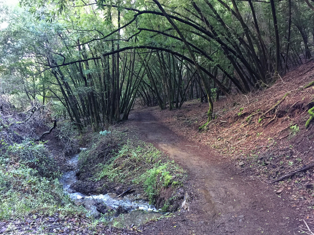
SHOTS FROM THE HIKE


2 thoughts on “Rancho San Antonio Open Space Preserve, Loop II”