Location: Cupertino, Santa Clara County
Hike Date: 2015, August 29
We were quite late to start with the hike – 5:30 P.M.! To add to the delay, we were unable to find a parking spot close to the trailhead; we drove up and down the Stevens Creek Canyon Rd to find a designated parking place. We finally ended up parking on the side of the road just next to the trailhead.
While driving south the first time, we went past the very scenic Stevens Creek Reservoir. We decided to stop here on our second round and enjoy the panoramic views while there was still ample light.


There is a huge, very well-shaded picnic area by the reservoir with plenty of parking space. We managed to strike a conversation with a patrolling officer here and it seemed it was okay to park on the roadside close to the trailhead.

So off we drove again down south and parked next to the Stevens Creek Tony Look trailhead.

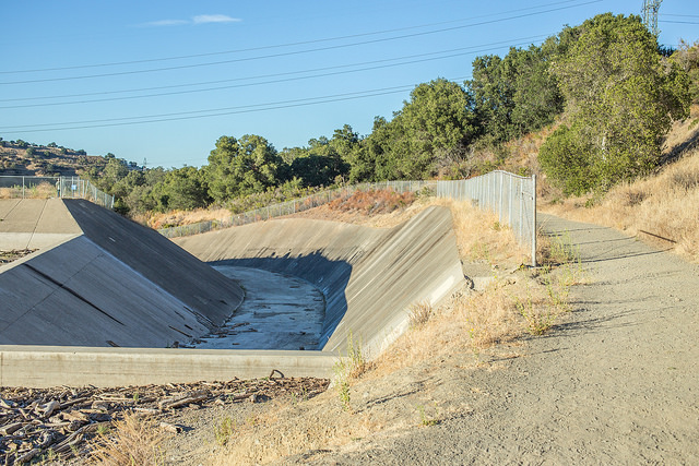
The trail is a pretty narrow dirt road, running along the hillside in parts and in open plains elsewhere. The slopes were all covered with dry leaves and grass at this time of the year.


We took this trailhead to walk up north and after a while the trail runs along the Stevens Creek and then the Stevens Creek Reservoir. If you notice from our route, we walked around the reservoir. The reservoir is huge and the walk is long.
These shots below show a dried up and parched Stevens Creek, yet another victim of the California drought.


After the initial distance of around a mile of shade and well-covered route, the trail becomes exposed to sun closer to the reservoir, scenic nonetheless with hilly backdrops. The tiny wooden bridges, intended to cross the (now dry) Stevens Creek, made the route interesting.


Us starting out late was going to have repercussions. We had earlier planned to do the Stevens Creek Tony Look Trail – Coyote Ridge Trail – Fern Trail route. However, with that route, we calculated that it would get dark by the time we reach our car and realized it might be safer to walk on the road than in the forested trail in low light.

We did go some distance on Coyote Ridge Trail (till the Fremont Older OSP Trailhead) but then retraced our steps back to the Stevens Creek Tony Look Trail and onto the Rim Trail to lead us to the Stevens Canyon Rd.

One of the reasons we still remember this hike is because of the last segment that we walked on road. It was a big relief to reach the car and to also find the car in one piece without any tickets.
******************************************************************************
Hike Date: August 29, 2015
Trails Hiked: Stevens Creek Tony Look Trail, Stevens Canyon Rd
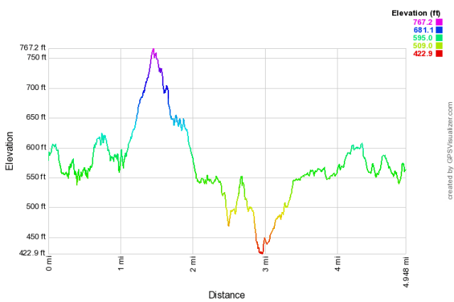
Distance Covered: 5.0 miles (8.0km)
Time: ~ 2h
Elevation Gain: 738ft
Max and Min Elevation: 734feet/404 feet
Trail Info
Parking Lot: We parked here on the Stevens Canyon Rd. We even drove to Sycamore Picnic Area but the parking lot there is reserved for people using the picnic area.

Parking Fee: None.

Restrooms: There are portable toilets at the county park's picnic area.

Map: None available at the trailhead. You can download one from here.

Exposure to sun: Well-covered for a mile, exposed around the Stevens Creek Reservoir.

Crowd: Sparse.
**************************************************************************

